
Climate Change Challenges for Forest Land Management
Land management practices have been increasingly difficult to implement due to the effects of climate change. Since 1895, average annual precipitation in Indiana has increased by about 15%, or about 5.6 inches, based on a linear trend. This trend is projected to continue, though the type of precipitation and when it falls are changing and will continue to do so.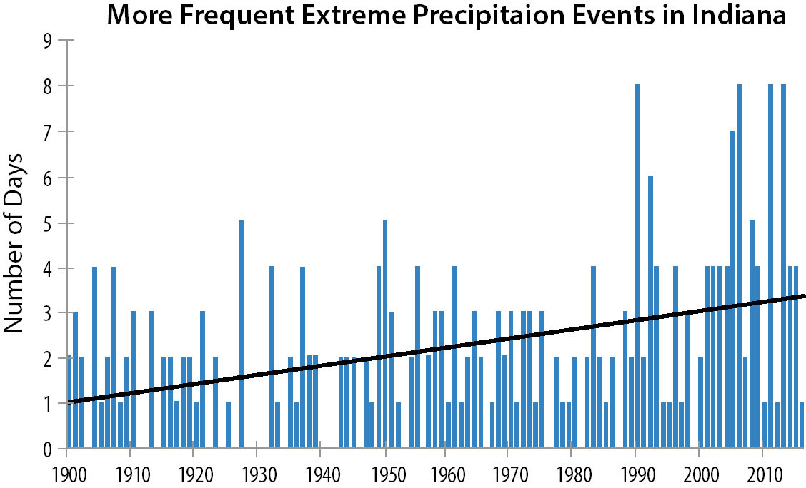 The number of days with precipitation events that exceed the 1900 to 2016 period's 99th percentile for Indiana (statewide average). The black line represents the trend line (0.2 days/decade) for the 1900 to 2016 period. Source: Midwestern Regional Climate Center.
Increased precipitation makes it even more difficult to manage the land for forestry needs. Any time land activities that require heavy equipment occur, such as: timber harvests, building/maintaining roads, constructing and maintaining ponds, building and maintaining stream crossing structures, building/maintaining trails, etc., soil and water resources are at risk from these disturbances. Work still needs to be performed on the land even though these precipitation events are happening more frequently. The challenge is to manage land with minimal disturbance between rain events as efficiently possible to reduce sedimentation and soil erosion loss and maintain soil productivity. This requires visual pre-monitoring and post-monitoring, proper implementation of project design and best management practices implemented during and after land disturbances.
Monitoring requires looking at how much rain fell and soil moisture conditions before planned management disturbances and observing conditions after management practices have been implemented and completed. When monitoring, landowners should ask:
• Has rutting or compaction changed natural surface run-off patterns? These changes can force water to move in different directions causing unwanted erosion in the form of rill, sheet, or head-cut erosion.
• Are loose excavated soils confined and secured from erosive waterways with vegetation, silt fences, etc.?
Erosion is a problem for two main reasons. First, it impacts water quality and aquatic habitat due to sedimentation. Second, it causes soil loss which impacts land productivity and stability for land use and vegetation growth. How productive are the soils after disturbance? Soils take nearly a century to develop and soil erosion happens at a much faster rate so soil conservation is extremely important.
One may ask, “What BMP’s can I employ to conserve soils and improve water quality during land management activities?” There are different practices utilized depending on the land management uses. All BMP’s are focused on minimizing human-induced erosion and sedimentation rates and maintaining soil productivity during and after land management disturbances.
The Forest Service utilizes a number of BMPs during timber harvesting to mitigate precipitation events. Compaction and rutting are reduced by prohibiting heavy equipment use when the soils are in a saturated condition, thereby reducing surface runoff, soil erosion and loss of soil nutrients. Rutting can reroute or block surface water drainage patterns causing issues with unexpected erosion in the long run. Compaction can also cause unforeseen long-term run-off erosion issues and loss of soil productivity. Some erosion control measures are: water bars and slash on slopes, subsoiling compacted soils, and establishing vegetation by seeding and mulching landings and skid trails after harvest. Landing subsoiled and planted with pollinator habitat on Hoosier National Forest.
Skid trails and haul roads all should be planned to reduce soil erosion and minimize surface water drainage impedance. Landings should try to be placed on flat ground with well drained soils. Soil types and topography should dictate the amount and intensity of disturbances to be allowed during harvests. Riparian buffers (stream vegetation) should be maintained. Vegetative buffers along streams hold stream banks in place, limiting erosion, and provide aquatic communities good water quality required to exist. The number of stream crossings should be limited to skid timber out. Try to leave floodplains and wetlands undisturbed, keep ditches and drainage structures clear of debris. Leaving floodplains undisturbed helps store overflows and excessive sediment and reduces channel incision of streams. Channel incision is a deep channel-cutting process which undermines channel banks due to concentrated flows without floodplain storage overflow. Channel incision will undercut dry useful land even though there are riparian buffers in place. Undersized stream crossing in Orange County, Indiana.
Road and trail construction also cause impairments to soils and water resources. Design of roads and trails should be done in consideration of natural topography and water drainage. Roads and trails need to be hardened based on traffic needs. Roads should be crowned and trails should be designed with dips to shed water. Designation of roads and trails should limit run-off impedance while not creating too many new waterway routes to form and erode. Stream crossings need to be large enough to allow bank full flows. If smaller structures are used, rapid bank erosion will occur due to turbulent flows caused by the crossing constriction. Crossings should also be appropriately armored with rock or vegetation. Undersized crossings also create passageway barriers to aquatic organisms. Beaver proof drainage structure at Roland Wetland, Hoosier National Forest
Pond and lake maintenance has now become a yearly observation and maintenance issue. Make sure the control structure is clear of debris to keep pool levels where they are needed and emergency spillways are working only during extreme events. You may need to beaver proof the control structure. Emergency spillways need to be examined for head-cutting and re-hardened with appropriate-sized rock or vegetation or the dam may breach eventually. Keep dams clear of trees by routine mowing or bushhogging. Trees roots will eventually ruin the integrity of the dam.
Keep in mind that emergency temporary mitigations may need to be utilized if design or implemented BMPs fail. Be prepared to install silt fencing or create sediment traps using staked straw bales, check dams made of rock/woody debris. Exposed soils may need to be blanketed with mulch, geotech fabric or staked straw netting. Terrain may have to be re-contoured to conserve soils. Creativity may be your only valuable design tool in an emergency mitigation.
The best laid out design and BMPs will not always guarantee that erosion issues will not occur. Water has a way of seeking the path of least resistance sometimes unseen by the human eye. Always monitor the activity afterwards and plan to mitigate unforeseen issues. As long as landowners are always monitoring and reacting, there will be less negative impacts to soil and water resources. Climate change requires us to never walk away and plan on always implementing adaptive post-mitigations and maintenance as needed.
Chad Menke is a hydrologist for the Hoosier National Forest.